Major wildfires in Southern California have led to urgent evacuation warnings across Los Angeles County. With strong Santa Ana winds fanning the flames, thousands of residents are now facing a race against time to leave their homes. The most significant of these fires—the Palisades fire—has already consumed more than 15,000 acres, devastating neighborhoods and prompting emergency measures from local officials.
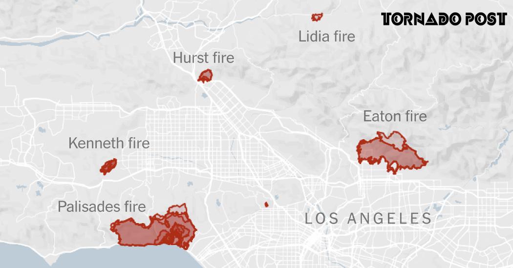
Maps: Tracking the Los Angeles Wildfires
Firefighters are working day and night to combat multiple wildfires that are growing out of control. The rapidly spreading flames and the accompanying smoke create dire situations for many communities. Local maps are being updated regularly to help residents track evacuation zones and understand the fires’ trajectories.
Extent of Recent Fires
- The Palisades fire has engulfed around 15,000 acres since it began earlier this week, heavily impacting lands between Santa Monica and Malibu.
- The Eaton fire, which is also dangerous, threatens over 37,000 structures in nearby Altadena, leading to mass evacuations.
- With wind gusts reaching up to 90 mph, fire conditions are worsening as firefighters struggle to control the flames.
Evacuation Areas
Officials have issued mandatory evacuation orders in certain neighborhoods as the fires encroach closer to residential areas. Residents are urged to evacuate immediately to ensure their safety. Meanwhile, air quality remains hazardous due to thick smoke, causing health officials to issue warnings to those in the affected zones.
Stories of Courage Amidst Chaos
Many families have shared their experiences as the fires approached. For instance, Brianna Navarro, an Altadena resident, had to evacuate with her family, but her 83-year-old grandmother, who lived alone, chose to stay behind. Tragically, Navarro now fears she may have lost her grandmother in the fire, describing her as a beloved figure in the community known for her kindness and leadership.
Official Response and Safety Measures
State Governor Gavin Newsom has mobilized additional resources, deploying over 900 firefighters to combat the wildfires. Apart from ground responses, air support is being directed to the fires, with helicopters transporting water to cool hot spots and prevent the flames from spreading further. Local agencies are also coordinating with community organizations to set up shelters and provide assistance for the displaced.
| Fire Name | Area Affected | Acres Burned | Evacuations |
|---|---|---|---|
| Palisades Fire | Santa Monica Bay between Malibu and Pacific Palisades | 15,000+ | Mandatory |
| Eaton Fire | Altadena | Threatens over 37,000 structures | Mandatory |
| Kenneth Fire | Calabasas and Hidden Hills | 960+ | Mandatory then downgraded |
The Community’s Call to Action
As firefighters battle these intense wildfires, community members are asked to stay informed through official channels for updates on evacuations and fire status. Local organizations are also coming together to provide support to those displaced, helping families find shelter and necessities as they navigate this challenging time. Now more than ever, the community’s unity is crucial in facing this crisis together.


