
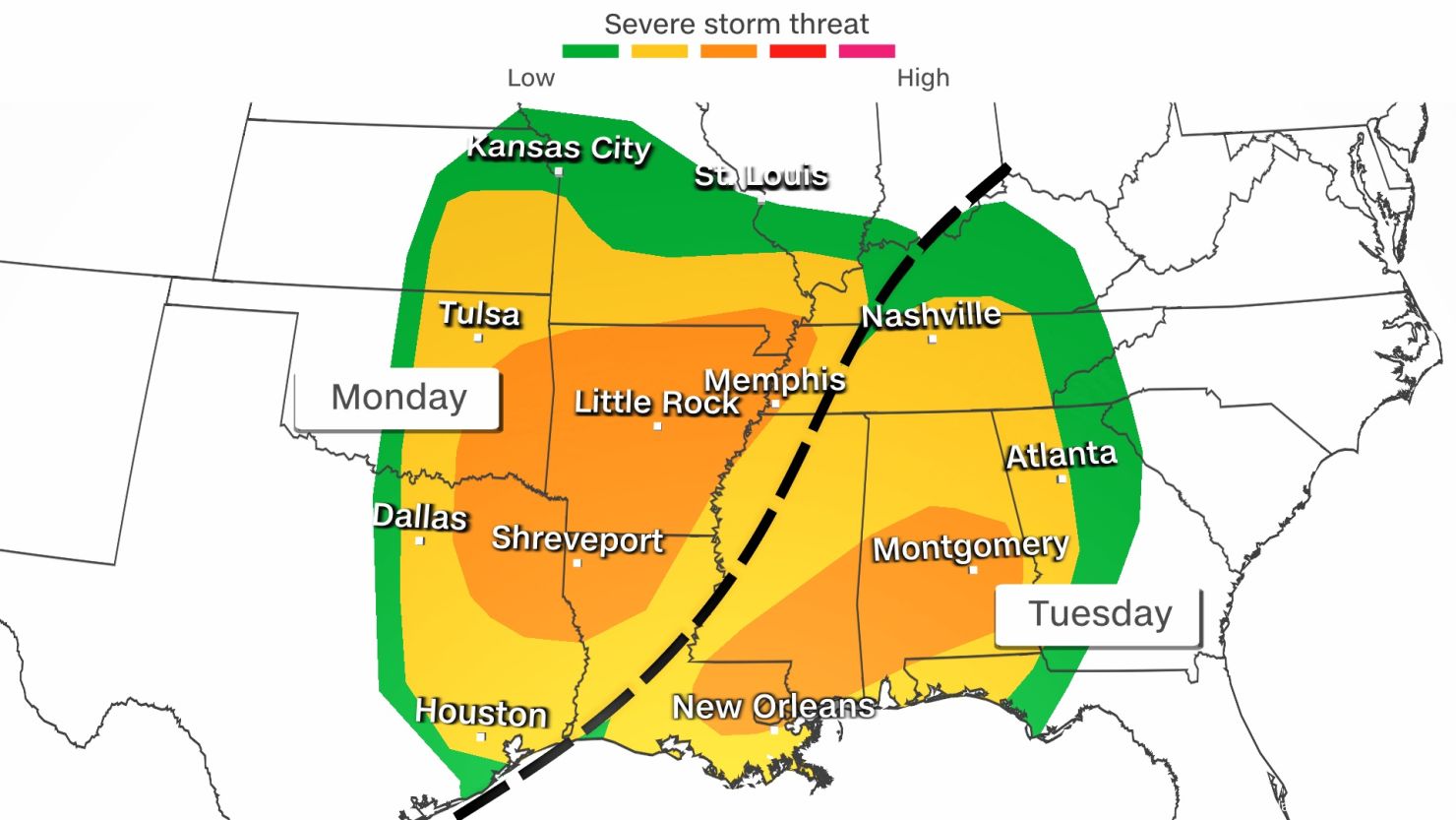
A major rainstorm is set to bring torrential downpours and possible flash flooding to northern Louisiana, prompting the National Weather Service (NWS) to issue a Flood Watch for much of the region, including Shreveport and Monroe.
The watch is in effect from early Tuesday morning through Wednesday evening, as forecasters warn that the storm could dump 2 to 4 inches of rain, with locally higher amounts possible. Areas with poor drainage or low-lying neighborhoods will be at the highest risk of flooding.
Officials are urging residents to prepare now as rainfall could quickly overwhelm roads, creeks, and streams, leading to dangerous conditions.
Which Areas Are Under Threat?
The Flood Watch covers a wide portion of northern and central Louisiana, including:
- Shreveport
- Monroe
- Bienville Parish
- Bossier Parish
- Caddo Parish
- Claiborne Parish
- Ouachita Parish
- Lincoln Parish
- Grant Parish
- De Soto Parish
- Natchitoches Parish
- Union Parish
- Webster Parish
These areas are expected to receive the heaviest rainfall, making flooding highly likely in flood-prone zones.
What to Expect from This Storm
This is not just another rainy day – forecasters say the storm system is powerful and slow-moving, increasing the risk of prolonged heavy rainfall and flash flooding.
- Heavy rain begins early Tuesday: Showers and thunderstorms will move in during the morning hours, with rain intensifying by afternoon.
- Flooding concerns peak Tuesday night into Wednesday: As rain continues, floodwaters may rise quickly, making roads impassable in some locations.
- Storm moves out by Wednesday evening: The rain will gradually taper off, but residual flooding could last for days.
How Bad Could the Flooding Get?
While rainfall totals of 2 to 4 inches may not seem extreme, it’s the intensity and duration of the rain that poses the biggest danger.
- Urban areas with poor drainage: Streets could flood within minutes of heavy downpours, making travel dangerous.
- Rivers, creeks, and bayous could overflow: Rising water levels in these areas could lead to widespread flooding in low-lying communities.
- Flash flooding in rural areas: Dirt roads and poorly paved highways could wash out, stranding residents.
How to Stay Safe During the Flood Watch
If you live in a flood-prone area, take action now to protect yourself and your property.
- Avoid Flooded Roads: Never attempt to walk or drive through floodwaters. Just six inches of moving water can knock you off your feet, and a foot of water can carry away a vehicle.
- Prepare Your Home: Clear out storm drains, move valuables to higher ground, and have sandbags ready if your area is prone to flooding.
- Stay Informed: Keep up with weather alerts via local news stations, NOAA radio, and official weather apps.
- Have an Evacuation Plan: If conditions worsen and an evacuation is needed, know your route and be ready to leave quickly.
What’s Next for Louisiana’s Weather?
The Flood Watch remains in effect until Wednesday evening, but the impacts of this storm could linger beyond that.
Looking ahead:
- Tuesday & Wednesday: Heavy rain and thunderstorms, temperatures in the upper 40s to mid-60s.
- Thursday: The storm clears out, but lingering clouds and cooler temperatures remain.
- Saturday: Another potential storm system could bring more heavy rain and severe weather to the region.
Final Warning: Take This Storm Seriously
Flash floods can develop faster than you think, turning streets into rivers within minutes. If you live in a low-lying area, take steps to protect yourself and your family now.


