
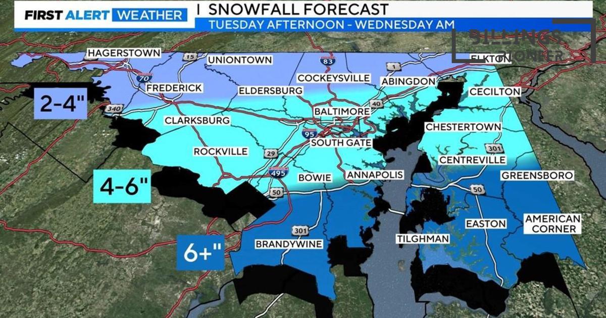
A significant winter storm is poised to impact Maryland from Tuesday afternoon into Wednesday, resulting in hazardous travel conditions across the region. A Winter Storm Warning has been issued for most of the state, with some areas expecting over six inches of snow. This storm is a serious weather event that could disrupt daily life, so it’s essential for residents to stay informed and prepared.
Baltimore Under Threat
As the storm approaches, Baltimore and its surroundings are on high alert. Snow is anticipated to begin in the afternoon, with heavier snowfall expected during the evening hours. If you live in or around Baltimore, make sure your plans account for potential delays and hazards on the road.
Timing & Impacts of the Storm
Snowfall is expected to start around midday Tuesday, with initial light snow quickly intensifying. This heightened snow rate can accumulate to 1-2 inches per hour, especially in southern Maryland. While the storm will initially be dry in the morning, the snow will take over early Tuesday afternoon, accumulating steadily throughout the day. Be aware that by Tuesday evening, travel could become very dangerous.
Weather Alerts and School Considerations
Schools in Maryland are also keeping a close watch on the weather situation. Depending on road conditions, decisions about school closures or delays will likely be made on Tuesday evening. Parents and students should stay tuned to local news for the latest updates, as weather conditions can change rapidly.
What to Expect After the Snow
Once the snow finally begins to taper off late Tuesday night into Wednesday morning, temperatures are predicted to rise, helping to improve road conditions slightly, but the chance of icy patches may linger throughout the day. Residents are encouraged to clear their driveways and sidewalks safely after the storm provides a break.
Another Wave of Precipitation
As the weather continues to shift, another wave of precipitation has been forecasted for Wednesday evening. This could introduce freezing rain and sleet, so keep your umbrellas handy as forecasters believe rain might wash over the snow shortly after. This situation will need ongoing attention because it may lead to additional travel issues and slowdowns.
End of the Week Outlook
The latter part of the week looks to be a bit unsettled, too. As temperatures fluctuate, highs are expected in the mid to upper 40s, but towards the end of the week, another cold snap may lead to lower temperatures in the 20s and 30s. It’s worth noting that the transition can create tricky spots for driving, as roads remain wet and freezing overnight.
Weekend Storm System on the Horizon
Weather watchers are also keeping an eye on a potential storm system that could take shape by late Saturday into Sunday, possibly bringing more rain to the area. Folks planning outdoor activities should be aware of the shifts in weather, as conditions may abruptly change.
Preparing for the Storm
- Stay updated with local weather reports and traffic information.
- Stock up on essential supplies, including food, water, and medications.
- Plan for possible power outages and ensure your phone is charged.
- If you must travel, do so with caution and allow extra time for your journey.
As this storm system approaches Maryland, the focus is on safety and preparedness. Residents are urged to monitor weather forecasts closely and make informed decisions to navigate any disruptions caused by heavy snow. Remember that staying safe is the priority!


