
MEDFORD, OR – Residents of Medford and surrounding areas should prepare for potential thunderstorms and strong winds as a storm system moves into the region on Wednesday. The National Weather Service forecasts a 30% chance of thunderstorms by 6 p.m., with lightning, gusty winds, and scattered showers expected to develop in the evening hours.
While the storm’s intensity is uncertain, forecasters warn that rapidly changing conditions could bring brief but strong thunderstorms. These storms pose risks to outdoor activities, travel, and power lines as they sweep through southern Oregon.
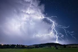
Storm Threats and Timing
The day will start off partly cloudy with mild temperatures, but by the afternoon, the atmosphere will become unstable, increasing the likelihood of thunderstorms.
If storms do develop, they could bring:
-
Lightning strikes, which pose fire hazards in dry areas.
-
Strong wind gusts, capable of knocking down tree branches and causing power outages.
-
Brief heavy rainfall, which may create slick roads and reduced visibility for drivers.
The primary window for thunderstorm activity will be from late afternoon through the early evening hours. Forecasters advise that storms could be brief but intense, so residents should stay prepared.
Precautions for Residents
With the potential for thunderstorms, lightning, and high winds, officials are urging residents to take the following precautions:
-
Secure Outdoor Items: Strong winds can send loose objects flying. Make sure patio furniture, garbage bins, and decorations are tied down or stored indoors.
-
Be Cautious While Driving: Roads may become slick, and wind gusts could impact high-profile vehicles. If visibility drops, slow down and turn on your headlights.
-
Stay Indoors During Thunderstorms: Lightning strikes are a serious hazard. If a storm develops, remain indoors and avoid standing near windows.
-
Prepare for Possible Power Outages: Have flashlights, extra batteries, and emergency supplies on hand in case of disruptions.
What’s Next?
After the storm system moves through, weather conditions should improve overnight, with partly cloudy skies expected on Thursday. However, meteorologists warn that additional storm systems could develop later in the week, so residents should stay updated with local forecasts.
Emergency services and power crews will be on standby in case of storm-related damage or power outages. The best way to stay safe is to monitor weather alerts and be prepared for rapidly changing conditions.
Stay Informed
Residents should follow the National Weather Service, local news stations, and emergency alerts for the latest updates. Storm conditions can change quickly, and staying informed is key to staying safe.
As always, when thunder roars, stay indoors!


