
GREEN BAY, WI – A messy and chilly weather pattern is setting up for Northeast Wisconsin, with rain showers expected to arrive Friday and continue through the weekend. While early forecasts suggested a mix of snow and ice, updated models indicate that precipitation will likely remain as rain, though temperatures will hover near freezing, raising concerns about possible slick roads.
What to Expect This Weekend
The National Weather Service predicts that clouds will dominate the skies starting Friday, with cooler temperatures and off-and-on rain showers persisting through Sunday. Here’s the breakdown:
-
Friday, March 28: Expect low clouds and light rain throughout the day. High temperatures will reach 46°F (8°C), with overnight lows dropping to 34°F (1°C).
-
Saturday, March 29: A couple of showers in the morning, followed by steady rain in the afternoon. The high will be 40°F (4°C), with a low of 35°F (2°C).
-
Sunday, March 30: Breezy and chilly with rain likely throughout the day. Highs will stay around 40°F (5°C), with lows dipping to 27°F (-3°C) overnight.
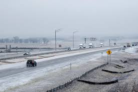
Although snow and ice accumulation are not currently expected, temperatures will be close enough to freezing that any overnight drop could lead to patchy slick spots on roads and bridges.
Possible Impacts of the Storm System
-
Slippery Roads: With wet conditions and cold nighttime temperatures, drivers should remain cautious, especially on bridges and overpasses, where surfaces cool faster.
-
Flooded Streets: Steady rain over several days may lead to water pooling on roads, especially in areas with poor drainage.
-
Cold, Damp Conditions: Wind chills could make it feel even colder, so anyone spending time outdoors should dress in layers and bring rain gear.
How to Stay Safe This Weekend
With the potential for raw, wet, and chilly conditions, here are a few ways to prepare:
-
Check the Forecast Frequently: Conditions can change quickly, and an unexpected drop in temperature could bring freezing rain or flurries to some areas.
-
Allow Extra Travel Time: Wet roads combined with near-freezing temperatures can create slick spots, especially in the early morning and late evening hours.
-
Dress for the Cold and Wet: Make sure to wear waterproof layers and warm clothing if you’re heading outside. Gusty winds and rain could make conditions feel even colder.
-
Prepare for Power Outages: While not expected, strong wind gusts mixed with damp conditions could cause isolated power outages. Have flashlights and emergency supplies on hand just in case.
Looking Ahead
After the storm system moves out, early next week is expected to remain chilly but dry, with temperatures gradually climbing back toward seasonal norms. However, forecasters are watching another potential system for the middle of next week, meaning Green Bay may not be done with stormy weather just yet.
Stay tuned to local weather updates to track any last-minute changes in the forecast.


