
Residents and travelers in the California-Nevada region should prepare for a blast of powerful winds as a strong weather system moves through, bringing gusts up to 65 mph. The National Weather Service has issued wind advisories for the Lake Tahoe and Pyramid Lake areas, warning of hazardous conditions through Thursday evening.
What to Expect
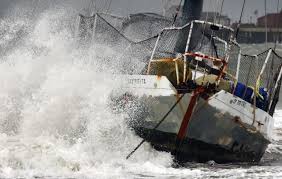
In the Lake Tahoe area, a Lake Wind Advisory remains in effect until 8 p.m. Thursday. Southwest winds will pick up speed, reaching 15 to 25 mph with gusts as high as 45 mph. These gusty conditions will create rough waters, with waves on the lake expected to reach up to 4 feet. Small boats, kayaks, and paddleboards could be in danger, and boaters are strongly advised to avoid the water until conditions improve.
Meanwhile, Pyramid Lake is under a High Wind Watch, with winds forecasted to be even stronger. Southwest winds between 25 to 35 mph will whip across the lake, with gusts of up to 60 mph in some areas. Along exposed roadways and highways—especially 395, 95, and 50—wind gusts could exceed 65 mph, making driving conditions dangerous. Waves on the lake could reach up to 5 feet, creating a serious risk for boaters and outdoor enthusiasts.
Potential Impacts
-
Travel Disruptions: High winds can make driving difficult, especially for high-profile vehicles like trucks, RVs, and trailers. Drivers should be extra cautious, particularly on exposed highways.
-
Boating Hazards: Large waves and strong gusts could make boating nearly impossible. Small boats and lightweight watercraft are at the greatest risk of capsizing.
-
Power Outages: The strong winds could bring down power lines and tree branches, leading to localized power outages.
-
Outdoor Risks: Loose objects such as patio furniture, decorations, and trash cans could easily become airborne, posing a danger to people and property.
How to Stay Safe
-
Secure Loose Items: If you have anything outside that could be blown away, bring it indoors or anchor it securely.
-
Avoid Boating: The choppy waters and high winds will make for extremely dangerous conditions on both lakes. It’s best to wait until conditions improve.
-
Drive Carefully: If you must be on the road, drive slowly and keep a firm grip on the wheel, especially in high-profile vehicles.
-
Stay Updated: Keep an eye on weather alerts from local news and the National Weather Service to stay informed on changing conditions.
Looking Ahead
These high winds are expected to die down by late Thursday evening, but until then, it’s important to stay alert and take necessary precautions. Whether you’re traveling, boating, or simply heading outside, be prepared for a gusty and potentially hazardous 24 hours. Stay safe and stay informed!


