
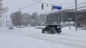
A major winter storm is on its way to northern Michigan, set to bring freezing rain, sleet, and snow starting Friday night and continuing through the weekend. Forecasters are warning residents to prepare for hazardous road conditions, possible power outages, and travel disruptions.
What’s Coming?
The system is expected to arrive late Friday afternoon, beginning as rain before temperatures drop and turn it into freezing rain and sleet. By Saturday, much of northern Michigan, including areas from Cadillac to Alpena, could be dealing with significant ice accumulation. The storm will continue through Sunday, with freezing rain giving way to wet, accumulating snow.
The worst of the icy conditions are expected in counties stretching from Petoskey and Gaylord to Alpena. Meanwhile, parts of the Upper Peninsula could see more snow than ice, with snowfall totals reaching several inches in some areas.
Potential Impacts
-
Treacherous Roads: The combination of ice and snow will make travel extremely dangerous. Roads, highways, and bridges may become slick and hazardous.
-
Power Outages: Ice buildup on power lines and trees could lead to outages across the region. Be prepared with flashlights, extra batteries, and alternative heating sources.
-
Fallen Trees & Property Damage: The weight of ice on tree limbs could cause them to snap, potentially damaging homes, vehicles, and power lines.
-
Flight Delays & Cancellations: If you’re planning to travel, check with airlines as the storm may cause disruptions at local airports.
How to Stay Safe
-
Limit Travel: If you don’t have to be on the roads, it’s best to stay home until conditions improve. If you must drive, use extreme caution, slow down, and allow extra stopping distance.
-
Prepare for Power Outages: Charge your devices, gather emergency supplies, and have a plan in case of an extended outage.
-
Check on Neighbors: Make sure elderly or vulnerable individuals have what they need to get through the storm.
-
Stay Informed: Monitor local forecasts, road conditions, and emergency alerts.
What’s Next?
Forecasters expect the worst conditions late Friday into Saturday before the system moves out by Sunday evening. Temperatures will remain in the 20s and 30s, meaning ice could linger, and roads may stay slick even after precipitation ends.
This storm is a reminder that winter isn’t over just yet. If you live in northern Michigan, now is the time to prepare. Stock up on essentials, have a backup power plan, and be ready to adjust weekend plans. The next few days could be rough, but with the right precautions, you can ride out the storm safely.


