
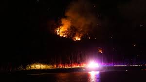
NEW YORK, NY – Residents of New York and New Jersey are urged to remain on high alert as a Red Flag Warning remains in effect until 8 PM Thursday. The National Weather Service has issued this warning due to a combination of strong winds, dry air, and low humidity, which could cause fires to ignite and spread rapidly.
Why the Fire Risk is High
Meteorologists warn that today’s weather conditions are perfect for wildfires. Wind speeds are expected to gust between 25 and 35 mph, and humidity levels will plummet to as low as 20-25%. This means any small flame, such as a cigarette, campfire, or spark from equipment, could quickly turn into a fast-moving fire.
The lack of recent rainfall has also left the ground dry, making trees, grass, and brush highly flammable. These conditions significantly increase the risk of wildfires, especially in open fields, wooded areas, and places with dead or dry vegetation.
Which Areas Are Most at Risk?
The Red Flag Warning covers a wide region, including New York City, Long Island, the Hudson Valley, and much of northern and central New Jersey. Local fire departments are already on high alert, as even a single spark could quickly turn into an out-of-control wildfire.
What You Should Avoid Today
With fire danger at a critical level, authorities are urging residents to avoid activities that could spark a fire, including:
-
Outdoor burning, including campfires and fire pits
-
Tossing cigarette butts on the ground
-
Using grills, fire pits, or fireworks in open areas
-
Operating machinery or power tools that create sparks, such as chainsaws or welding equipment
Firefighters warn that if a fire does start, it could spread so quickly that controlling it may become nearly impossible before it causes damage.
When Will the Fire Risk End?
Relief is on the way, but it won’t come until late Thursday night, when a cold front moves through the region. This will bring cooler temperatures, increased humidity, and possibly some rain, which should help lower the fire risk by Friday morning. However, some forecasters warn that dry and breezy conditions could return over the weekend, so residents should remain cautious.
How to Stay Safe
With conditions as dangerous as they are, everyone must take extra precautions to prevent fires. Officials recommend:
-
Reporting any sign of smoke or fire immediately to local authorities
-
Following local burn bans and fire safety guidelines
-
Keeping a fire extinguisher or water source nearby if using outdoor equipment
-
Staying updated on weather alerts from official sources
By remaining aware and taking small steps, residents can help prevent potentially devastating wildfires.


