
MARQUETTE, MI – A winter storm has arrived in Marquette, bringing dangerous ice conditions and heavy snowfall that will impact the region through Sunday. The storm, which began moving in late Friday evening, is expected to bring a mix of freezing rain, sleet, and snow that will create treacherous road conditions and pose a significant safety threat.
Freezing Rain and Snow Hit Marquette
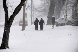
Marquette residents should brace for icy roads and heavy snow as the storm continues to intensify. The forecast predicts that up to 4 inches of snow could accumulate by Saturday morning, with more snow expected to fall throughout the weekend. The storm will bring a combination of freezing rain and snow, making it difficult for road crews to keep streets clear.
The heaviest snow will fall Saturday afternoon into the evening, reducing visibility and making travel nearly impossible at times. Freezing rain could cause dangerous ice accumulation, especially on bridges and untreated roadways, creating an added danger for drivers. In addition to the snow, wind gusts of 25 mph will whip the snow around, making driving even more difficult.
Dangerous Travel Conditions
As the storm progresses, the Michigan Department of Transportation (MDOT) is urging people to avoid unnecessary travel, particularly during the evening hours when conditions will be at their worst. Roads will be slick, and black ice will form quickly, especially during the night and early morning hours.
“Dangerous conditions are expected through the weekend, with icy roads and low visibility making it challenging to get around,” said a spokesperson for MDOT. “If you must travel, take extra precautions, reduce your speed, and be prepared for slippery spots.”
Drivers should expect hazardous conditions on bridges, overpasses, and untreated roads, where ice will accumulate quickly. Be mindful of blowing snow that could further reduce visibility, making it even harder to see other vehicles on the road.
Potential Power Outages and Cold Weather
Along with snow and ice, the winter storm could cause power outages in the area, as ice accumulation on power lines and trees may lead to downed lines. Residents are advised to have emergency supplies on hand in case of a prolonged outage.
Once the snow moves out, a cold front will settle in, bringing dangerous wind chills by Saturday night. The temperature is expected to drop well below freezing, and wind chills could make it feel like -10°F or colder. This extreme cold poses a serious threat for frostbite, especially for anyone exposed to the cold for extended periods.
Staying Safe During the Storm
-
Avoid traveling unless necessary. If you must travel, drive slowly and be prepared for hazardous conditions.
-
Carry an emergency kit with food, water, and blankets in your car in case you get stranded.
-
Stay indoors when possible to avoid the cold and ice.
-
Monitor local forecasts and road conditions to stay informed.
-
Check on neighbors, especially the elderly, to make sure they are safe and have heat and supplies.


