
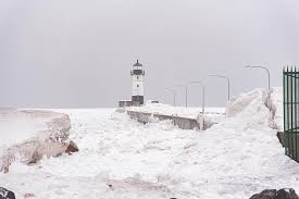
DULUTH, MN – A powerful winter storm is poised to bring a wintry mix of snow and ice to the Duluth area, with up to 4 inches of snow expected by Saturday morning. The Minnesota Department of Transportation (MnDOT) is warning residents to prepare for slippery roads and dangerous travel conditions throughout the weekend.
Hazardous Winter Weather Moving In
The storm, which is expected to begin affecting the region Friday afternoon, will bring a combination of snow, sleet, and freezing rain. Temperatures near the freezing mark will make roadways extremely dangerous, particularly on bridges, overpasses, and untreated surfaces. The snow will be heavy at times, leading to reduced visibility and possible whiteout conditions.
The heaviest snowfall is expected to occur Friday evening into Saturday morning, with up to 4 inches of snow possible in some areas. Duluth and its surrounding cities are likely to see the most significant accumulations, though localized heavier amounts could occur.
Travel Delays and Dangerous Roads
As the storm progresses, MnDOT is urging drivers to limit travel if possible, as ice and snow will quickly cover roads, creating hazardous conditions. Black ice is likely to form, especially during the night and early morning hours when temperatures are at their lowest.
“Drivers should be prepared for slick and icy roads as snow and freezing rain begin to accumulate,” said a MnDOT spokesperson. “We are treating the roads in advance, but travel will still be dangerous in some areas.”
Wind gusts of up to 25 mph will exacerbate the situation by creating areas of blowing snow, which will further reduce visibility and make driving even more challenging.
Cold Weather to Follow the Storm
Once the snow moves out, cold Arctic air will settle in over the region. Temperatures are expected to plummet into the teens and single digits by Saturday night, with wind chills making it feel much colder. Those heading out Saturday evening or Sunday morning should expect bitterly cold conditions.
The Minnesota Department of Health is advising residents to take precautions against frostbite and hypothermia, particularly if they are planning to be outside for extended periods.
Safety Tips for the Storm
-
Avoid unnecessary travel if possible, especially during the evening and overnight hours.
-
Drive cautiously and reduce speed if you must be on the roads. Allow extra time to reach your destination.
-
Keep an emergency kit in your car, including blankets, food, water, and a flashlight in case you get stuck.
-
Stay informed by checking local forecasts and road conditions regularly.
-
Check on neighbors, especially the elderly and those who may be more vulnerable to the cold.


