
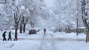
Parts of Wisconsin and Minnesota are bracing for a dangerous ice storm that is expected to impact travel, power, and daily life through Sunday night. With warnings already in place, residents in areas like Phillips and Silver Bay are being urged to take extra precautions as freezing rain begins to accumulate, creating hazardous conditions on the roads.
Why Are Ice Storm Warnings in Effect?
The National Weather Service has issued ice storm warnings for parts of Wisconsin and Minnesota due to the combination of freezing rain, ice accumulation, and hazardous driving conditions. The storm will bring a layer of ice that will form on roads, trees, and power lines, making travel risky and increasing the possibility of power outages.
-
Freezing Rain: As rain falls and meets the freezing ground, it will immediately freeze, creating a dangerous layer of ice on surfaces.
-
Accumulative Ice: The ice is expected to accumulate up to half an inch in some areas, making driving nearly impossible in spots.
-
Slippery Roads: Untreated roads, bridges, and sidewalks will become particularly slippery, and visibility will be poor, further complicating travel.
What’s the Impact on Travel?
The ice storm will affect travel, especially in areas like Phillips and Silver Bay, where conditions are expected to be the worst. Here’s what drivers can expect:
-
Icy Roads: Major highways like I-35 and I-94 will be impacted, making travel slow and dangerous.
-
Power Outages: The weight of the ice could bring down tree branches and power lines, leading to widespread power outages. Residents are advised to keep flashlights, extra blankets, and non-perishable food on hand.
-
School Closures: Several schools in the affected areas are planning to close, and more closures could follow as conditions worsen. Check local news sources for the latest updates.
How to Stay Safe During the Ice Storm
If you live in or near the impacted areas or are planning to travel, it’s important to take the following safety measures:
-
Avoid Travel: If possible, stay indoors and avoid driving until conditions improve. If you must travel, drive slowly and cautiously, and keep an emergency kit in your car.
-
Emergency Kit: Pack your vehicle with essentials such as blankets, snacks, water, a first aid kit, and a fully charged phone. Also, make sure your car has enough gas in case of delays.
-
Prepare for Power Outages: Have flashlights, extra batteries, blankets, and enough food and water to last through potential power outages. Stay indoors and avoid unnecessary exposure to the cold.
-
Monitor Weather Updates: Keep an eye on the latest weather alerts and road conditions. Conditions can change rapidly, so stay informed via local news or official weather updates.
When Will Conditions Improve?
While the worst of the storm is expected to last through Sunday night, there is hope for improvement as temperatures rise into Monday. This will transition the freezing rain to plain rain, helping to melt the ice on roadways. However, lingering patches of ice may still cause hazardous driving conditions for the first part of the week.
What’s Next for Wisconsin and Minnesota Weather?
After the ice storm, cold temperatures will remain, but there won’t be any more major storms on the horizon in the immediate future. However, drivers are still advised to remain cautious, as ice can stick around longer than expected, particularly in shaded areas or high altitudes.


