
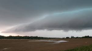
A major storm system is set to bring tornadoes, large hail, and damaging winds to the East Coast on Monday, affecting 14 states from Georgia to Pennsylvania. Meteorologists are warning millions to stay vigilant as the storm could unleash severe weather with the potential for widespread destruction.
What to Expect
The National Weather Service has issued warnings for severe thunderstorms capable of producing:
-
Tornadoes: Some tornadoes could be strong and long-lasting, making them especially dangerous.
-
Large Hail: Hailstones could reach up to 2 inches in diameter, potentially causing damage to vehicles, roofs, and crops.
-
Damaging Winds: Wind gusts could reach 70 mph, capable of knocking down trees, power lines, and causing widespread power outages.
-
Flash Flooding: Heavy rainfall could total up to 3 inches, leading to localized flooding, especially in urban areas with poor drainage systems.
Where and When the Storms Will Hit
The storm will likely develop in the early morning hours across Georgia and the Carolinas, moving northeast throughout the day. The worst of the severe weather is expected to hit the Mid-Atlantic region in the afternoon and evening, before reaching the Northeast by Monday night.
-
Morning to Early Afternoon: Storms will begin affecting Georgia, South Carolina, and North Carolina.
-
Afternoon: The storm will move north, reaching Virginia, Maryland, and Washington, D.C., with the highest risk for tornadoes and hail.
-
Evening to Night: Philadelphia, Pittsburgh, and areas of New Jersey will experience the peak of the storm’s strength.
Which Areas Are Most at Risk?
Severe storms are expected to impact areas including Atlanta, Charlotte, Washington, D.C., Baltimore, Philadelphia, and Pittsburgh. Areas in the Mid-Atlantic and Northeast, such as New Jersey, Delaware, and parts of New York, will also face risks, with tornadoes and high winds threatening the region.
How to Prepare
With this storm expected to bring dangerous conditions, experts advise residents in affected areas to:
-
Stay Informed: Keep an eye on local weather updates through news stations, weather apps, or NOAA weather radio.
-
Have a Plan: If a tornado warning is issued, seek shelter in a basement or interior room on the lowest floor of your home.
-
Prepare for Power Outages: Charge your phone, stock up on water, flashlights, and batteries, as power outages are likely.
-
Avoid Travel: If possible, stay indoors during the height of the storm. Driving could be hazardous due to hail, strong winds, and flash flooding.
Looking Ahead
The storm will likely move out of the East Coast by Tuesday, but the risk for severe weather may extend into the Northeast as the system moves offshore. Cooler, calmer weather will follow in the storm’s wake, but the damage caused by tornadoes, hail, and flooding could last for days.
As spring weather ramps up, meteorologists urge everyone to remain prepared and take weather warnings seriously. Now is the time to review your emergency plan and ensure you have the necessary supplies.


