
AUSTIN, TX — A powerful storm system is making its way through Central Texas, bringing a heightened risk of heavy rain, damaging winds, and isolated tornadoes through Friday evening. The National Weather Service (NWS) has issued alerts across the region, warning residents of the potential for flash flooding and severe thunderstorms.
Storms Could Bring Flooding and Tornadoes
Forecasters say this storm system has the potential to dump 2 to 4 inches of rain across the region, with some areas seeing up to 6 inches. This raises the threat of flash flooding, particularly in low-lying areas and urban streets where water can rise quickly.
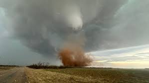
But rain isn’t the only concern. Isolated tornadoes are also possible, particularly along and east of the I-35 corridor, where conditions are favorable for rotating thunderstorms. Wind gusts exceeding 60 mph could knock down power lines and trees, leading to potential power outages.
Timing of the Storms
-
Thursday Night: Scattered storms will begin developing, some of which could become severe with heavy rainfall and intense lightning.
-
Friday Morning: The storm system strengthens, bringing a higher risk of damaging winds and possible tornadoes.
-
Friday Afternoon & Evening: The peak of the storm. Expect the heaviest rain, strongest winds, and highest tornado potential before the system moves out late Friday night.
By Saturday morning, skies should begin to clear, with cooler and drier conditions expected for the weekend.
How to Stay Safe
With severe weather on the way, residents should take extra precautions:
-
Monitor updates: Keep up with alerts through local news, weather apps, or a NOAA Weather Radio.
-
Prepare a safe space: If a tornado warning is issued, head to a windowless interior room on the lowest floor.
-
Avoid flooded roads: Just six inches of water can knock a person off their feet, and a foot of water can sweep away a car. Turn around, don’t drown.
-
Charge devices: Power outages could occur, so make sure phones and flashlights are fully charged.
-
Secure loose items: Strong winds could turn patio furniture, trash bins, and outdoor decorations into dangerous flying debris.
Looking Ahead
After the storms clear out, Saturday and Sunday will bring relief with partly cloudy skies and cooler temperatures in the mid-70s. But until then, Central Texas residents should stay alert and prepared for what could be a dangerous weather event.


