Vermont is gearing up for a powerful winter storm that will bring heavy snow, sleet, and ice across the state this weekend. A Winter Storm Warning has been issued for the region, with up to 9 inches of snow expected in some areas, alongside dangerous ice accumulation that could cause significant disruptions. The storm is expected to start on Saturday evening and will continue through Sunday evening, potentially affecting travel and daily activities throughout the state.
What to Expect: Snow, Ice, and Hazardous Conditions
The storm will begin impacting Vermont on Saturday evening, bringing a mix of snow, sleet, and freezing rain. As temperatures hover around the freezing mark, the storm will deposit heavy snow and ice across the state, making conditions hazardous for travel. Snowfall rates could reach up to 2 inches per hour at times, particularly in higher elevations.
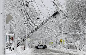
The combination of snow and ice will create dangerous roads and sidewalks, and visibility will be reduced in many areas. Ice accumulation could be significant, particularly in southern and central Vermont, potentially leading to downed tree limbs and power outages. The heaviest snow will fall Saturday night through Sunday morning, with icy conditions lasting into Sunday evening.
Travel Impacts and Road Closures
Vermont’s roadways are expected to be heavily impacted by the storm. Interstate 89 and Interstate 91, as well as many secondary roads, will become slippery and dangerous, especially on Sunday when snow and ice accumulation is at its peak. Driving conditions will be treacherous, and authorities are urging people to stay off the roads if possible. For those who must travel, it’s important to leave extra time for trips and drive carefully, allowing more distance between vehicles.
Residents in rural areas and higher elevations, particularly in the Green Mountains, should be prepared for severe conditions and may experience longer delays for road-clearing efforts. Icy patches on the road could lead to accidents, and frostbite could become a risk for those stranded in their vehicles for extended periods.
Power Outages and Safety Precautions
With ice accumulation expected, the risk of power outages is high across the state. The weight of the ice could cause tree limbs and power lines to snap, leaving some homes without electricity. Utility companies are on standby, but restoration efforts may take longer due to the challenging conditions.
Residents are advised to prepare for power outages by having flashlights, batteries, and extra blankets on hand. Keeping a battery-powered radio to stay updated on the storm’s progress is also recommended. Additionally, it’s a good idea to stock up on essential supplies such as food, water, and medications in case of prolonged outages.
What Areas Are Most Affected?
While the storm will affect the entire state, certain areas will see the heaviest snow and ice accumulation.
-
Mount Mansfield and Stowe are expected to receive up to 9 inches of snow, with ice accumulation as well.
-
Burlington and Winooski could see 5-7 inches of snow with moderate icing.
-
Middlebury and Montpelier are likely to receive 6-8 inches of snow.
-
Southern Vermont, including Brattleboro and Bennington, may see 4-6 inches of snow and significant ice accumulation, particularly on Sunday morning.
How to Stay Safe During the Storm
To stay safe during the storm, follow these tips:
-
Limit travel to essential trips only.
-
Stay indoors whenever possible and avoid walking on icy sidewalks.
-
Keep your phone fully charged in case of power outages.
-
Clear snow and ice from driveways and walkways to prevent injuries.
-
Check on elderly neighbors or those who may need assistance during the storm.
Conclusion: Be Prepared for Impact
This weekend’s storm is expected to cause significant disruptions in Vermont, from hazardous road conditions to power outages. With up to 9 inches of snow and dangerous ice accumulation, the storm poses a serious threat to safety and daily routines. Residents should take all necessary precautions and stay updated on weather forecasts as conditions evolve. The combination of snow, ice, and freezing temperatures will make this one of the most severe winter events in Vermont this season.


