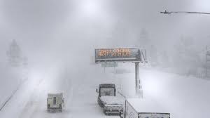
A powerful winter storm is set to bring heavy snowfall, strong winds, and hazardous travel conditions to the Sierra Nevada region, with accumulations of up to 3 feet expected in higher elevations around Lake Tahoe. The storm is forecast to continue through 11 PM Monday, bringing dangerous whiteout conditions and icy roads across California and Nevada.
Major Snowfall Expected in Sierra Nevada
The National Weather Service has issued a Winter Storm Warning for the region, urging residents and travelers to prepare for severe winter weather. The heaviest snowfall is expected in the Sierra passes, including Donner Summit and Echo Summit, where travel could become extremely difficult or even impossible at times.
Expected snowfall totals:
-
Higher elevations (above 7,000 feet): 2 to 3 feet of snow
-
Lower elevations (below 7,000 feet): 6 to 12 inches
-
Reno and Carson City: Light snowfall accumulations with rain mixing in at times
In addition to the heavy snowfall, wind gusts up to 55 mph in the valleys and over 80 mph on mountain ridges will create blizzard-like conditions and reduce visibility to near zero in some areas.
Hazardous Travel Conditions Expected
Authorities are urging caution for anyone traveling through the region, especially on Interstate 80 and U.S. Highway 50. Chain controls are expected to be in place, and possible road closures may occur if conditions worsen.
-
Low visibility and icy roads could lead to major traffic delays.
-
Avalanche danger is increasing in backcountry areas due to heavy snowfall and wind loading.
-
Power outages are possible due to the combination of heavy snow and high winds.
When Will the Storm End?
The worst of the storm is expected Sunday night into Monday, with snowfall gradually tapering off by late Monday evening. However, cold temperatures will persist, leading to continued icy conditions into Tuesday morning.
Safety Tips for Residents and Travelers
-
Avoid unnecessary travel—If you must drive, carry an emergency kit, extra food, water, and blankets.
-
Check road conditions before heading out via Caltrans (California) or NDOT (Nevada).
-
Prepare for power outages—Charge devices and have flashlights ready.
-
Stay indoors and off mountain roads if possible.
With up to 3 feet of snowfall, strong winds, and dangerous travel conditions, residents and visitors to the Lake Tahoe region should take this storm very seriously and plan accordingly.


