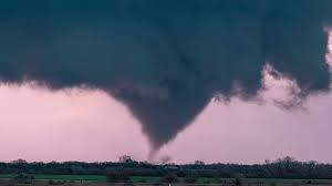
Kansas residents should brace for a volatile night of severe weather, with tornadoes, massive hail, and damaging winds expected to develop after 6 PM Tuesday. Meteorologists are warning of an escalating storm system that could bring life-threatening conditions to central and eastern Kansas.
The National Weather Service has issued alerts, urging communities in the region to prepare for sudden and intense storms. Powerful winds, flash flooding, and hail larger than golf balls are among the biggest threats, along with isolated tornadoes capable of significant destruction.
What to Expect: Tornadoes, Hail, and High Winds
This storm system is packing multiple threats, making Tuesday night especially dangerous. Here’s what residents should prepare for:
-
Tornado Risk: The atmospheric setup supports the development of isolated tornadoes, with the greatest risk concentrated in central and eastern Kansas.
-
Large Hail: Some storms may produce hail up to the size of tennis balls, capable of damaging cars, windows, and rooftops.
-
Damaging Winds: Gusts could reach 70 mph, strong enough to topple trees and power lines, leading to potential power outages.
-
Heavy Rain & Flash Flooding: Repeated downpours may lead to localized flooding, particularly in low-lying areas and poor drainage zones.
Timing and Affected Areas
-
Storm development begins after 6 PM, with the most dangerous weather expected between 8 PM and midnight.
-
The highest risk zone includes cities like Wichita, Topeka, and Kansas City.
-
Storms will weaken as they move eastward, but dangerous conditions could persist overnight.
How to Stay Safe Before and During the Storm
-
Have a Plan: Identify a safe shelter area in case a tornado warning is issued.
-
Charge Devices & Prepare for Power Loss: Strong winds could cause widespread outages.
-
Protect Vehicles & Property: Move cars into garages or covered areas to avoid hail damage.
-
Stay Indoors & Avoid Travel: Driving in severe weather can be extremely dangerous due to low visibility and flooded roads.
What’s Next: Cooler Temperatures and Lingering Winds
By early Wednesday morning, the storm system will move out, leaving behind cooler temperatures and breezy conditions. However, forecasters warn that additional storms may redevelop later this week, so residents should stay alert for further weather updates.
With tornadoes, destructive hail, and damaging winds in the forecast, Kansas residents must take this severe weather threat seriously. Stay informed, stay indoors, and stay safe.


