
Durango, CO – A winter weather alert has been issued for southwest Colorado and southeast Utah as a powerful snowstorm moves through the region, bringing slick roads, snow accumulation, and challenging travel conditions through Thursday. Snow is expected to accumulate up to 8 inches in some areas, making travel hazardous, especially for those heading into the mountains.
Snowfall to Impact Travel Through Thursday
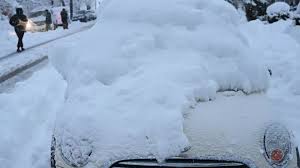
The snowstorm is already impacting parts of southwest Colorado and southeast Utah, with heaviest snowfall expected overnight and into the early morning hours of Thursday. Local weather forecasters are predicting accumulations of 4 to 8 inches of snow in many areas, particularly in higher elevations.
As the storm progresses, interstates and state highways, especially those in the San Juan Mountains and near Cortez and Durango, will likely see slushy, snow-covered roads that will be slick and treacherous. I-70, US-160, and US-491 are expected to be impacted, and drivers are advised to exercise extreme caution.
The National Weather Service (NWS) is also warning of reduced visibility, which could lead to dangerous driving conditions. Motorists should avoid unnecessary travel during the peak snowstorm hours, and those on the roads are urged to slow down and stay alert for snowplows and other traffic.
Impact on Daily Activities
While the snowstorm will be disruptive for travelers, it will also have an impact on local businesses, schools, and outdoor activities. Many schools in the region are already reporting delays and closures, and ski resorts are preparing for increased snow accumulation, which will improve conditions for skiers but make access to mountain roads more challenging.
Outdoor enthusiasts are encouraged to plan before heading out for hiking or snowboarding. Snowshoes or skis may be necessary in areas with deep snow, and those venturing into the mountains should be prepared for cold temperatures and wind chills that could make conditions feel much colder than the actual temperature.
What to Expect for the Rest of the Week
The snowstorm will continue to bring snow to the area until Thursday afternoon, with precipitation expected to taper off by late Thursday. While the heaviest snow will fall during the night and morning hours, the storm will leave behind slick and icy roads, so travelers should remain cautious even after the snow has stopped.
Once the storm clears, Friday will bring milder conditions with partly cloudy skies and less snowfall, but the snow-covered roads will likely remain icy into the weekend. Sunshine will return to the region, but some isolated slippery spots may remain on highways and local roads.
Preparing for Winter Weather
If you plan to travel through southwest Colorado or southeast Utah, here are a few tips to ensure your safety:
-
Check road conditions: Before traveling, be sure to check local road conditions and weather forecasts, especially if you plan to travel through the mountains.
-
Winterize your vehicle: Make sure your car is equipped with winter tires, windshield washer fluid, and an emergency kit that includes blankets, food, and water.
-
Dress warmly: If you’re heading outdoors, wear layers, a hat, gloves, and sturdy boots to stay warm and dry.
-
Drive safely: If you must drive, slow down, maintain a safe distance from other vehicles, and avoid sudden braking. Chains may be required on some mountain roads.


