
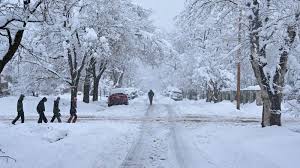
Denver, CO – A Colorado weather alert is in effect as snow is set to impact the Denver metro area and the I-70 corridor from Thursday through early Friday. The storm is expected to bring heavy snowfall to parts of the state, disrupting travel and making road conditions hazardous, especially along high-altitude routes.
Snow Expected to Begin Thursday Afternoon
The snow will begin in the late afternoon hours on Thursday, as a cold front moves into Colorado. Forecasters predict that the Denver metro and areas along the I-70 corridor, including Golden and Boulder, will see the heaviest snowfall during the evening commute. Snow totals are expected to reach 3-6 inches in many areas, with some parts of the Foothills and mountain passes potentially receiving up to 10 inches of snow.
The National Weather Service (NWS) has issued Winter Weather Advisories for many areas, advising travelers to expect slippery roads, low visibility, and difficult travel conditions throughout the evening and into the overnight hours.
Impact on Travel and Road Conditions
The storm is likely to cause significant travel disruptions, particularly for those traveling along I-70. The mountain passes, including the Eisenhower Tunnel and Vail Pass, are expected to see dangerous conditions with snow accumulation, making travel treacherous for both commuters and truckers. Chain laws may be enacted for vehicles traveling through these areas, and drivers are urged to check road conditions before heading out.
In the Denver area, heavy snow may lead to delays at airports and could complicate evening commutes, so those with travel plans should prepare for possible delays. Local authorities are working to clear roads as quickly as possible, but those planning to drive are encouraged to use caution and consider alternative routes or delaying travel if possible.
Snowfall Continues Into Early Friday
The snow will continue overnight and is expected to taper off by early Friday morning. While snowfall is expected to end by 7 AM Friday, the morning commute may still be affected by snow-covered roads and lingering hazardous conditions.
With temperatures expected to remain near freezing, any moisture on the roads will likely refreeze overnight, leading to the possibility of slick spots and black ice Friday morning. Drivers are urged to take extra care during the early hours of the day.
What You Can Do to Prepare
With the forecast calling for snow and potentially dangerous conditions, here are a few tips to help you prepare:
-
Drive cautiously: Slow down and leave extra space between you and other vehicles. Use winter tires if available, and carry chains if you’re heading into the mountains.
-
Monitor travel updates: Stay informed about road conditions and flight delays by checking local news, the Colorado Department of Transportation (CDOT) website, and the airport’s website for real-time updates.
-
Winterize your vehicle: Make sure your car is ready for the cold weather by checking the battery, tire pressure, and windshield wipers.
-
Have an emergency kit: Pack essentials like blankets, water, snacks, and a flashlight in case you get stranded during the storm.
Looking Ahead: Drier Conditions for the Weekend
Once the snow clears, the weather should improve by Friday afternoon, with sunny skies and warmer temperatures expected to return for the weekend. This storm is expected to be short-lived, but it’s important to stay alert and safe during its duration.


