
St. Cloud, MN – A weather alert has been issued for St. Cloud and Sauk Rapids, as snow-covered roads are expected to persist through 1 AM Thursday. The National Weather Service (NWS) is warning that slick, icy conditions will make travel difficult for the next several hours, particularly on major highways and side streets in the region.
Snowfall to Affect Roads Until Thursday Morning
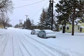
The recent snowstorm has left several inches of snow on the ground in St. Cloud and Sauk Rapids, creating hazardous driving conditions. Accumulations of 2 to 4 inches of snow are expected, and snow-covered roads will remain slick, making it challenging for drivers to navigate safely.
The NWS advises travelers to avoid unnecessary trips through the affected areas if possible, as slippery spots are expected on I-94, US-10, and local streets. Those who must be on the roads should reduce speed, keep a safe distance from other vehicles, and be prepared for sudden patches of ice that may appear in unexpected places.
Risk of Accidents and Travel Delays
Due to the ongoing snowfall and icy conditions, accidents and sliding vehicles are a significant concern, especially on overpasses and bridges that tend to freeze first. The Minnesota State Patrol has reported an increase in minor accidents on highways throughout the region.
“Travel is dangerous in St. Cloud and Sauk Rapids due to snow and ice buildup,” said NWS meteorologist Emily Granger. “If you must go out, please be cautious, and allow extra time to get to your destination.”
How to Stay Safe During the Storm
As snow continues to fall, drivers and pedestrians should take extra care on the roads. The NWS recommends:
-
Slowing down: Even if roads don’t look icy, there could still be hidden ice patches that make driving dangerous.
-
Equipping your vehicle with winter tires and having an emergency kit on hand that includes a blanket, food, water, and a flashlight.
-
Avoiding sudden stops: If you must stop or slow down, do so gradually to avoid skidding.
-
Walking cautiously: Sidewalks and parking lots are also prone to icy conditions, so wear proper footwear and move slowly to avoid slipping.
When Will Conditions Improve?
The snow is expected to taper off by late Wednesday evening, with skies clearing as temperatures drop. However, the snow-covered roads will persist into the early hours of Thursday morning, and conditions are not expected to fully improve until after 1 AM Thursday.
By Thursday morning, conditions will gradually improve as road crews continue to clear the snow. However, some icy patches may linger throughout the day, so drivers should remain cautious even after the storm passes.


