
Kentucky – A Flash Flood Warning has been extended across several parts of western Kentucky as life-threatening flood conditions continue to escalate. The National Weather Service (NWS) is urging residents of Christian, Muhlenberg, Todd, and Trigg Counties to seek higher ground immediately, as rising water levels threaten roads, homes, and entire neighborhoods.
Torrential Rain Triggers Flash Flood Emergency
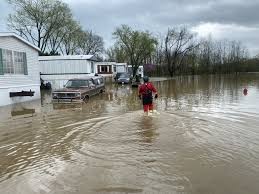
The warning, which remains in effect through Saturday evening, follows hours of intense rainfall that has overwhelmed creeks, rivers, and drainage systems in the region. Emergency officials have reported roads under water, stranded vehicles, and flooded basements as relentless downpours continue to batter the area.
The most impacted towns so far include Hopkinsville, Elkton, Greenville, and Cadiz, where floodwaters have closed local streets and threatened low-lying homes.
NWS Warns of “Life-Threatening Situations”
In a statement issued early Saturday, the National Weather Service in Paducah stressed the seriousness of the threat. “This is a life-threatening situation. Do not attempt to travel unless you are fleeing an area subject to flooding or under an evacuation order,” the warning stated.
With 1 to 3 inches of rain already fallen and more on the way, water levels are rising quickly, leaving little time to act. Some areas could see total accumulations of 4 to 6 inches, especially in flood-prone valleys and near rivers.
Travel, Schools, and Power Affected
Several roads have been closed in affected counties, including portions of Highway 41, US-68, and KY-181, due to water overtaking lanes or eroding pavement. Local school districts are monitoring conditions closely, with potential closures or delays expected by Monday if cleanup takes time.
As of Saturday afternoon, power outages have also been reported in parts of Muhlenberg County, where utility crews are working to access flooded substations and downed lines.
What Residents Should Do Right Now
Authorities are asking residents to:
-
Move to higher ground immediately if you are in a flood-prone zone.
-
Avoid all travel unless necessary.
-
Never attempt to drive through flooded roadways – “Turn Around, Don’t Drown.”
-
Keep cell phones charged in case of power outages or emergency alerts.
-
Monitor local media and NWS alerts for updates.
Emergency shelters are being set up in several counties to support those displaced by rising waters. Residents can contact their county emergency management office for the nearest shelter location.
Forecast: When Will It End?
The heavy rain is expected to ease by early Sunday morning, though standing water and residual flooding could last into Monday. Clearer skies and cooler temperatures are forecast for early next week, giving local agencies time to assess and repair the damage.


