
Oklahoma – A Flash Flood Warning has been issued for parts of southeastern Oklahoma, with heavy rainfall already creating hazardous conditions across Latimer, Le Flore, and Pushmataha Counties. The warning, issued by the National Weather Service (NWS), will remain in effect until 10:15 PM Saturday, but conditions may continue to deteriorate even after that.
Dangerous Rainfall Triggers Flood Emergency
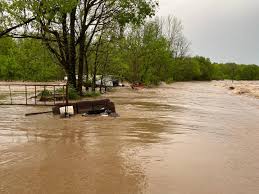
Strong storms moving through the region have dumped 1 to 3 inches of rain in a short period, and forecasters say even more could fall before the night is over. With ground already saturated, many low-lying areas are quickly becoming overwhelmed, prompting concerns of flash flooding in urban areas, rural roads, and along creeks and rivers.
The NWS in Tulsa has urged residents in flood-prone areas to take action immediately. “Flash flooding is ongoing or expected to begin shortly,” officials warned. “This is a dangerous situation. Do not attempt to travel unless you are fleeing an area subject to flooding.”
Specific Areas at Risk
The warning covers a wide area, including towns like Wilburton, Talihina, Poteau, and Antlers. These communities have seen moderate to heavy rainfall for much of the afternoon, and conditions are expected to worsen into the evening.
Flood-prone roads, underpasses, and rural routes could become impassable. Authorities are especially concerned about creeks and drainage systems, which are likely to overflow due to the volume of rain in a short period.
Travel Disruptions and Safety Precautions
Local law enforcement and emergency responders are advising residents to avoid driving after dark, as many roads may be submerged or washed out. Even a few inches of moving water can sweep away a car, and flooded roadways may hide deep sinkholes or debris.
Residents are urged to:
-
Stay off roads if possible, especially in low-lying areas.
-
Move to higher ground immediately if you’re near a flood-prone zone.
-
Avoid walking or driving through floodwaters – they may be deeper or faster-moving than they appear.
-
Stay tuned to local news and weather alerts for updates throughout the night.
More Rain Possible Overnight
Meteorologists say that while storms will gradually begin moving out of the area after 10 PM, additional rainfall is still possible overnight. Even small amounts of extra rain could worsen the flooding situation, especially in already-saturated locations.
Residents should remain on alert through the evening and into Sunday morning, as localized flooding and damage assessments will likely continue after the rain stops.


