
Just when it seemed like spring was here to stay, Northern Pennsylvania is getting hit with a harsh reminder that winter isn’t done just yet. Forecasters say a mix of rain and snow will move through the region tonight, Saturday, April 12, bringing slippery roads, reduced visibility, and potentially dangerous travel conditions to several counties across the northern tier of the state.
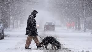
This sudden return of winter weather is being driven by a coastal storm system moving up the East Coast. The storm is pulling cold air down from Canada, clashing with the warmer spring moisture to create an ugly blend of precipitation. Areas at higher elevations are likely to see snow, while lower regions will deal with a cold rain—possibly turning into sleet or wet snow as temperatures drop overnight.
Cities like Erie, Williamsport, and Scranton are already seeing light rain and drizzle this evening, with temperatures lingering in the upper 30s. As the night progresses, forecasters expect those temperatures to dip just enough to allow snow to mix in, especially in areas north of Interstate 80 and in the mountainous regions. Accumulations aren’t expected to be significant—most areas will see less than an inch—but it doesn’t take much for roads to become slick and dangerous.
Motorists are being urged to take precautions, especially if traveling tonight or early Sunday morning. The Pennsylvania Department of Transportation (PennDOT) has crews ready to respond if roads begin to ice over. Drivers should reduce their speed, keep their headlights on, and allow extra time for their commute if travel is necessary. Bridges and overpasses will be the first areas to freeze, and black ice may be a hidden danger overnight.
While April snow isn’t unheard of in Pennsylvania, it always manages to catch people off guard. Many residents have already packed away their winter coats and snow tires, making this evening’s shift back to winter weather feel even more jarring.
The National Weather Service has not issued a full Winter Weather Advisory for all counties yet, but local forecasters are warning that the combination of cold air, precipitation, and slick roads is enough to cause concern. Overnight lows are expected to drop to the low 30s, meaning even areas that see only rain could face freezing conditions by early morning.
Looking ahead, the wet and chilly pattern is expected to stick around for at least a couple more days. Temperatures will remain below normal, with highs on Sunday struggling to reach the mid-40s, and more showers are possible into next week.
Residents are advised to check the latest forecasts, stay off the roads if possible, and prepare for one more round of winter before spring returns in full. As tonight proves, in Pennsylvania, winter has a habit of sneaking back when you least expect it.


