
A powerful winter storm is making its way across Colorado and Utah, bringing heavy snowfall, icy roads, and dangerous travel conditions. The National Weather Service has issued a Winter Weather Advisory, warning that up to 10 inches of snow could accumulate by Saturday evening.
With the storm hitting just ahead of the busy holiday weekend, residents and travelers should expect major disruptions, particularly in higher elevations, mountain passes, and ski resort areas. Officials are urging people to prepare for hazardous conditions, plan ahead, and avoid unnecessary travel if possible.
What to Expect: Timing & Snowfall Totals
The storm is expected to intensify overnight Friday into Saturday, with snowfall rates increasing by early morning.
- Thursday Night – Early Friday: Light snow will begin falling, accumulating gradually overnight.
- Friday Morning – Saturday Afternoon: The heaviest snowfall will occur during this period, with snow accumulating at a rate of up to 1 inch per hour in some areas.
- Saturday Evening: Snow showers will start to taper off, but cold temperatures will keep roads icy and slick well into Sunday morning.
Total snow accumulations could reach:
- 6 to 10 inches in the mountains and higher elevations.
- 3 to 6 inches in lower elevations and valleys.
- More than 10 inches in localized spots along the Wasatch and Rocky Mountain ranges.
Where Will the Storm Hit the Hardest?
In Colorado, the storm is expected to have a major impact along the I-70 corridor, especially in areas west of Denver and into the Rocky Mountains. The Colorado Department of Transportation warns that heavy snow and ice will make driving extremely difficult, particularly for travelers heading to and from ski resorts.
In Utah, the Wasatch Mountains and urban corridors along I-15 will see some of the worst conditions. The Salt Lake Valley, Park City, and Provo could experience intense snow showers and whiteout conditions, particularly on Saturday morning.
Officials have warned that Lake-enhanced snow showers could make conditions even worse along the Bountiful and Salt Lake County areas, where additional snowfall is likely.
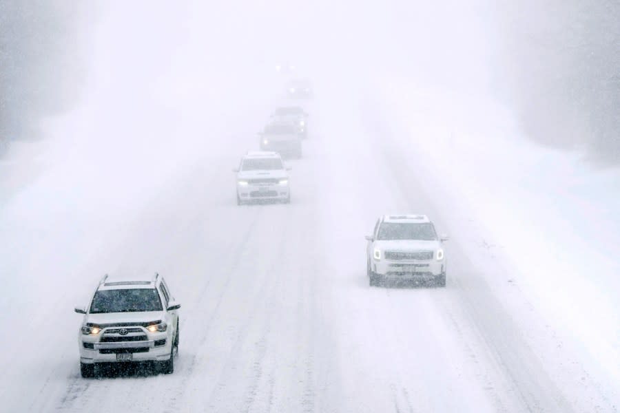
Travel Alert: Stay Off the Roads If Possible
If you’re planning to travel, be prepared for delays, road closures, and icy conditions. Officials strongly advise avoiding unnecessary trips during peak snowfall hours.
For those who must drive, follow these winter safety precautions:
- Slow down and increase your following distance. Snow and ice will greatly reduce traction, making stopping distances longer.
- Avoid sudden braking or sharp turns to prevent skidding.
- Keep an emergency kit in your car, including blankets, water, non-perishable food, a flashlight, and extra phone chargers.
- Check road conditions before leaving—both Colorado DOT and Utah DOT provide real-time updates on road closures and weather alerts.
Bridges, overpasses, and shaded areas will freeze first, creating dangerous black ice conditions. Visibility may also be severely reduced in areas experiencing heavy snowfall and strong winds.
Could This Storm Cause Power Outages?
While this storm is primarily a snow event, heavy accumulations could weigh down tree branches and power lines, leading to isolated power outages. Residents in higher elevations should be prepared for temporary disruptions by charging devices and having flashlights, batteries, and backup heat sources available.
When Will Conditions Improve?
The storm is expected to weaken by late Saturday night, with lingering snow showers continuing into early Sunday morning. However, cold temperatures will cause snow and slush to refreeze overnight, meaning icy roads and hazardous travel conditions could persist well into Sunday morning.
Final Word: Be Prepared & Stay Safe
This storm will bring significant snowfall, cold temperatures, and hazardous driving conditions across Colorado and Utah. If you don’t absolutely need to travel, it’s best to stay home and wait for conditions to improve. Those heading to ski resorts should expect longer travel times and possible delays on mountain roads.
Stay updated with local weather alerts and road conditions, and make sure you’re prepared for anything this storm throws your way.


